
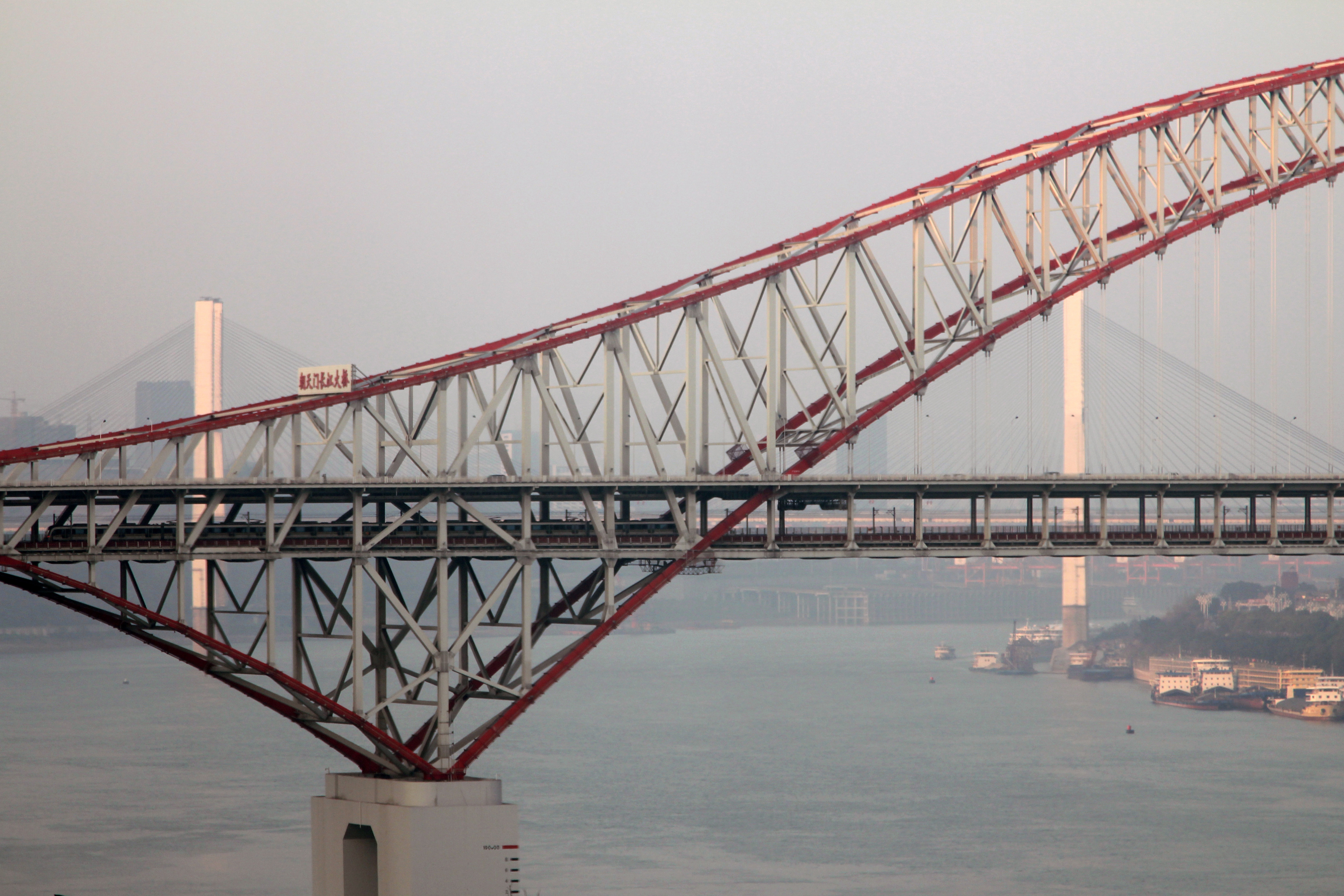
Chongqing's bridges reward a closer look than a skyline photograph. In four structures you can compare an arch, a suspension system, and two related bridges where cables and steel trusses work together. The point of this guide is to help you recognize what you are seeing from lawful public areas, then choose a manageable outing. You do not need to cross any bridge to use it.
Start with three things to look for
First find the deck: the horizontal structure carrying traffic. Then follow the visible supports above it. An arch rises in a broad curve; a suspension bridge has a main cable that dips between towers, with smaller hangers descending to the deck; a cable-stayed bridge has inclined cables running directly between tower and deck. Finally, look for a truss, the repeated triangular framework that stiffens and supports a span.
These are observation aids, not a complete engineering explanation. Individual bridges combine systems, and a photograph cannot establish structural condition. Try sketching the outline with three lines before photographing it: deck, principal support, and tower or arch. You will notice differences that decorative lighting can hide.
Chaotianmen: read the arch before the skyline
Search for 朝天门长江大桥, not simply 朝天门. The bridge links Nan'an with the former Jiangbei area, now part of Liangjiang New Area downstream from the peninsula's river confluence; a navigation result for Chaotianmen Square can lead to a different destination. Completed in 2009, it uses a steel-truss arch and a two-level traffic arrangement. The rail crossing belongs to the Loop Line. Municipal bridge profile November 2025 administrative change
From an open public riverbank in the Danzishi-side or opposite-bank area, choose an angle that separates the arch from the buildings behind it. Look for the relationship between the curved upper outline and the much straighter traffic levels. The lattice is part of the structure, not decoration. Moving a short distance along an authorized path may reveal the depth between the two sides, but there is no reason to enter an approach ramp or maintenance area.
An oblique view can be more informative than standing directly under the bridge: it helps you see both the curve and the layered deck. This is a separate bridge study, not a promise of a continuous riverside walk from downtown.
Egongyan: follow the hanging curve

The Egongyan road and rail bridges, photographed 15 August 2019. Visible construction around the rail bridge belongs to the 2019 scene, not a current work report. Photo: MNXANL, via Wikimedia Commons. License: CC BY-SA 4.0. Original file used unchanged.
Use the name 鹅公岩长江大桥 for the older road bridge and 鹅公岩轨道专用长江大桥 when identifying its rail neighbour. The road bridge opened in 2000. Its original pedestrian paths were removed in a later widening project, so do not plan to walk onto the road bridge. Official history
For this guide, choose a permitted bank-side position in the Jiubin Road area or an open public area on the opposite bank. First identify the main cable's sagging profile, then the thinner hangers and the horizontal deck. The neighbouring structures can overlap from some angles; establish which deck you are following before labeling a photograph. A zoomed detail is useful only after you have understood the whole outline.
There is also an invisible part of the story: anchorage. Engineering research describes the older bridge's east-side tunnel anchorage, reminding us that suspension systems depend on much more than their photogenic towers. This is background knowledge, not an invitation to find or enter the anchorage. Original engineering study
Dongshuimen: two towers and a strong horizontal line

Dongshuimen Bridge, photographed from the Xinhualu cableway station on 28 October 2025. This image does not establish free public access to the viewpoint. Photo: DvTor8303, via Wikimedia Commons. License: CC0 1.0. Original file used unchanged.
Dongshuimen (东水门长江大桥) crosses the Yangtze between Yuzhong and Nan'an. For an observation stop, consider an open public riverfront in the Dongshuimen area or the Longmenhao-side area, after checking the actual entrance and riverbank level. The historic district's lanes and the bridge approach are not interchangeable routes.
Look for two main towers, inclined cables, and the steel truss along the deck. Its related bridge, Qiansimen, shares the same design family. The designer describes the pair as partially cable-supported girder bridges: both the substantial girder structure and the cables matter. Road traffic uses the upper level, while Line 6 runs below. Designer project description
The useful viewing question is not merely “Where is the prettiest tower?” Ask how the deck continues across the river and where the cables meet it. If buildings hide one tower, use a wider open view rather than chasing a risky angle. The photograph here is a historical reference taken from the Xinhualu cableway station; it does not establish free access to that viewpoint.
Qiansimen: a related design with one main tower

Qiansimen Bridge with lifebuoys in the foreground, photographed 12 May 2025. A historical scene, not a current access report. Photo: 王桁霽, via Wikimedia Commons. License: CC BY-SA 4.0. Original file used unchanged.
Qiansimen (千厮门嘉陵江大桥) crosses the Jialing, not the Yangtze. Its one main tower makes a useful comparison with Dongshuimen's two. Look from an open public bank-side area around the Hongyadong side or Jiangbeizui side, keeping clear of stairs, entrances and crowd-flow routes. An appearance in a popular photo does not make a location a public viewing platform.
Compare the tower's curved outline, the cables meeting the deck, and the long truss. An original interview with one of the designers explains that keeping the city visually open helped shape the choice of a single cable plane. The towers' shuttle-like outline is another deliberate design feature. Designer interview
Daylight is particularly useful for this comparison: you can distinguish members against the sky without waiting for an illumination schedule. If the riverside area is crowded, stay farther back or choose another permitted public position rather than blocking a passage for a symmetrical shot.
Choose a comparison, not a four-bridge marathon

Original planning schematic. Not to scale and not a walking or navigation map; verify each public approach separately.
For a first architecture outing, pair Dongshuimen and Qiansimen as two separate central-city stops. The common design language makes the differences easier to see. Travel between their surrounding neighbourhoods using a currently available route; do not assume the road tunnel linking the bridge system is a pedestrian connection.
For stronger structural contrast, choose Chaotianmen and Egongyan as separate Yangtze outings, with transport between them. Their arch and suspension silhouettes are easier to distinguish than two superficially similar cable-supported bridges. Trying to add all four in one walk can turn observation time into route-finding time. This grouping is editorial planning advice, not a timed or field-tested itinerary.
At each stop, make three images if space allows: a broad context view, the principal support system, and one detail taken without leaning over a barrier. Record the bridge name and river immediately so similar red structures are not confused later. You do not need a drone, a cruise ticket, or access to a bridge deck for this exercise.
Check access at the level where you will actually stand
Before setting out, check weather, current police or district notices, the exact public entrance and your return transport. A pin close to the river may sit above or below your intended path. Where step-free access matters, verify the whole approach, not just whether an elevator is mentioned in an old article.
Follow barriers, staff instructions and temporary flood or crowd controls. Stay off exposed riverbed, closed steps, service roads, bridge maintenance structures and railway areas. Never ask a driver to stop on a bridge, ramp or traffic lane for a photograph. If the public route ends, turn back. Historical photos and engineering descriptions confirm neither today's access nor today's operating conditions.
About this guide and the October holiday
Original desk research was checked on 4 October 2026 UTC; structural sources, the administrative correction and travel cautions were rechecked on 5 October 2026 UTC. The September holiday transport announcement describes different rail-service extensions by line. Police-sourced holiday reporting also warns of dynamic traffic controls around central river crossings. Neither gives this guide a universal last-train time or guarantees pedestrian access to a particular bridge approach. Check the current notices and the exact entrance you intend to use before leaving.
The four photographs are dated historical references. Named bank-side areas are possible observation locations, not surveyed routes or confirmed open entrances. No on-site visit, structural safety assessment, step-free audit or human editorial review is claimed.
Frequently asked questions
Q: Do I have to walk across the bridges?
A: No. This guide is designed around lawful public-bank observation. The older Egongyan road bridge lost its pedestrian paths during widening. Access to any separate walkway must be checked on the day; it is not assumed here.
Q: Which two bridges are best for a first architecture comparison?
A: Choose Dongshuimen and Qiansimen to compare a related design with two main towers versus one. Choose Chaotianmen and Egongyan for an arch-versus-suspension comparison, treating them as separate outings with transport between.
Q: Are Dongshuimen and Qiansimen both over the Yangtze?
A: No. Dongshuimen crosses the Yangtze, while Qiansimen crosses the Jialing. They are related parts of a road-and-rail connection, but the connecting road tunnel is not a walking itinerary.
Q: Is a night visit better for understanding the structures?
A: Daylight often makes the trusses, cables and separate traffic levels easier to distinguish. Night lighting can be attractive, but this guide does not verify lighting times or promise a particular display.
Q: Are these viewpoints guaranteed to be open or step-free?
A: No. The named bank-side areas are planning options, not verified entrances or continuous accessible routes. Check the exact road level, public entrance, stairs or lifts, temporary barriers, weather and return journey before committing.
Traveler comments
Share a recent experience or ask a practical question about this guide.