

Cover illustration: AI illustration based on a historical photograph. Rongchang Wanling’s roofscape beside the Laixi River and a low, flat crossing. Reference by Tang Yi / Xinhua, captured 2026-06-13 and published by HNNTV on 2026-06-14. Architecture and viewpoint are approximate; not evidence of current conditions, public access or a navigation route.
Historical reference only; original photographs kept for internal reference, not republished; no reuse license established: HNNTV / Xinhua / Tang Yi (唐奕)
This guide includes four labeled AI illustrations and one original localized observation and planning card for Wanling in Rongchang. The actual photographs remain internal reference-only, with no reuse license established and no originals republished. The river overview and lower Darong Bridge approach use Tang Yi / Xinhua references captured on 2026-06-13 and published by HNNTV on 2026-06-14. The street and upper archway detail use iChongqing references published on 2021-01-31; EXIF records 2020-10-13, but camera-clock accuracy is not independently verified and the timezone is unspecified. Those photographers are uncredited. Architecture and viewpoints are approximate, not current conditions, access confirmation or navigation evidence. No independent review is claimed.
Wanling Ancient Town in 2026 is a Rongchang riverside visit centred on historic streets, gates and communal buildings. The town government's December 2025 directory distinguishes free, all-day town entry from 09:00–18:00 heritage-building hours. Plan around the Laixi River and reconfirm individual interiors; older references call the same settlement Lukong.
Save 重庆荣昌万灵古镇 for navigation, and keep 路孔古镇 as the useful older name. The municipal civil-affairs history published on 1 July 2024 records the change from Lukong to Wanling in 2013. These are not two competing attractions that need separate itinerary slots.
This guide was researched on 1 October 2026. It proposes a way of reading the settlement, rather than a field-tested circuit. The latest facility directory found is dated December 2025, so its opening information is a planning baseline that still needs checking before travel.
Begin with the river and the slope
Wanling's setting is the starting point for understanding it. The 2014 environmental assessment hosted by the World Bank, in its cultural-relic section, describes streets following the Laixi River and buildings adapted to rising ground. It identifies Darong Bridge, Huguang Guild Hall and the Zhao ancestral temple as significant sites.
Find an authorised viewpoint where you can relate the riverside buildings to the lanes above them. Look for how entrances, roofs and connecting passages respond to different levels. Rather than photographing only a row of façades, try to understand how a person moves between the water and the streets.
The assessment concerns a historical infrastructure project. Its boundaries and construction statements should not be used as a present-day visitor map, flood assessment or access permit. For your walk, use current signs and the route confirmed locally. A bridge visible across the river is an orientation landmark, not proof that every approach to it is open.

AI illustration based on a historical photograph. Wanling’s wet stone-paved old street, timber shopfronts, deep eaves and red lanterns. Reference published by iChongqing on 2021-01-31; photographer uncredited. EXIF records 2020-10-13, but camera-clock accuracy is not independently verified and the timezone is unspecified. Architecture and viewpoint are approximate; not evidence of current conditions, public access or a navigation route.
Historical reference only; original photographs kept for internal reference, not republished; no reuse license established: iChongqing / Photographer not credited
Let Darong Bridge explain connections, not just scenery
Darong Bridge, 大荣桥, is a useful focus because it connects the two sides of the landscape. At a permitted viewing position, consider what a crossing changes: people can reach markets, communities can maintain relationships across the water, and a town can serve travellers as well as residents. Those are questions to explore through local interpretation, rather than a claim about every period of the bridge's use.
The primary histories and the English environmental assessment use different structural descriptions. This guide therefore avoids repeating a precise arch type, span count or an unsupported claim about how much original fabric remains. A photograph alone is not enough to settle those questions. If engineering history is your interest, check the on-site heritage plaque or seek specialist interpretation.
Treat the crossing as part of a pedestrian network. Before walking across, establish whether there is a permitted return route and whether companions are comfortable with its surface and edges. You do not need to cross just to complete a checklist. A safe viewpoint that reveals the bridge's relationship with the town can serve the historical purpose equally well.
Read the gateways and community buildings
The civil-affairs account of 1 July 2024 describes a fortified settlement developed during the Qing Jiaqing period and names four gates: Taiping, Shizi, Hengsheng and Riyue. Save the Chinese forms 太平门, 狮子门, 恒升门 and 日月门 if you want to recognise them on signs.
Choose one accessible gate and examine how the street passes through it. Notice the change between an outside approach and the space within, and look for a plaque distinguishing the history of the gate from later repair. Then locate another gate on the current map. This turns several attractive structures into evidence of an organised settlement.
There is no need to reach all four. Closed approaches, building works or a tiring climb can make a shorter selection the better visit. Do not follow a narrow passage into someone's home simply because a navigation line appears to continue. Nor should an old account of a well or underground feature be treated as an invitation to explore it.

AI illustration based on a historical photograph. Only the upper roof and eaves detail of Wanling’s old-street archway. Its sign is physically below the new composition, outside the frame; no whole-gate identity or entrance access is asserted. Reference published by iChongqing on 2021-01-31; photographer uncredited. EXIF records 2020-10-13, but camera-clock accuracy is not independently verified and the timezone is unspecified. Architecture and viewpoint are approximate; not evidence of current conditions, public access or a navigation route.
Historical reference only; original photographs kept for internal reference, not republished; no reuse license established: iChongqing / Photographer not credited
Compare a guild hall with an ancestral hall
Two places with impressive halls can tell different social stories. Huguang Guild Hall, 湖广会馆, relates to networks of migrants and people with shared regional origins; the Zhao ancestral hall, 赵氏宗祠, centres a family lineage. The official place-name history connects these buildings with migration into the area. Read the labels carefully rather than treating every courtyard as another temple.
If both are open, compare what each display emphasises. Does it discuss a place of origin, a shared deity, education, family rules or remembrance? A short note on these differences is more useful than simply counting halls visited. Where interpretation is only in Chinese, a translation tool can help with a photographed label if photography is permitted.
The existing Huguang Guild Hall and Dongshuimen guide provides a separate urban Chongqing comparison. Its ticket and access details do not transfer to Wanling's hall. Sharing a name or institution type does not mean that two buildings are branches of the same visitor attraction.
Interiors may also be places of community use. Give worshippers and local activities space, observe photography rules, and avoid touching woodwork or objects. If entry is closed, appreciate what can lawfully be seen from the public route rather than looking for an unofficial side door.
Distinguish town access from building hours
The Wanling town government's directory dated 9 December 2025 lists the ancient town as free and open all day. It separately gives 09:00–18:00 for the Lukong historic building group, naming Huguang Guild Hall, the Zhao ancestral hall and Sansheng Palace. This is a concrete reason not to equate an open street with an open exhibition.
The same directory gives 023-46219128 for enquiries about the town and heritage group. Ask which interiors are open on your date, whether any temporary restrictions apply and where to start. The listing does not certify that every room is accessible throughout those hours, or that special activities carry no charge.
An all-day street listing also does not make an after-dark visit the most useful choice for reading architecture. Daylight helps with labels, uneven surfaces and return navigation. If you want evening atmosphere, establish which facilities and transport remain available after your planned meal. Avoid arriving late with several indoor stops still essential to your itinerary.

AI illustration based on a historical photograph. Only the lower stonework of the Darong Bridge approach: short stair, masonry support, arched passage and low, flat bridge edge. The frame ends below the upper pavilion and signs; neither is shown. Reference by Tang Yi / Xinhua, captured 2026-06-13 and published by HNNTV on 2026-06-14. Architecture and viewpoint are approximate; not evidence of current conditions, public access or a navigation route.
Historical reference only; original photographs kept for internal reference, not republished; no reuse license established: HNNTV / Xinhua / Tang Yi (唐奕)
Plan a slower visit and the Rongchang connection
The 2021 iChongqing feature presents Wanling through riverside commerce, migration and local food. Treat that as an invitation to leave time for a meal, rather than a promise that the town will be quiet or that a particular shop will still operate.
A practical choice is to eat after your first heritage stop, when you know the remaining distance and opening window. Check the menu before sitting down. Ask about spice, stock, meat and serving size if those affect your choice. Dishes presented as local specialties can vary between businesses; the label alone does not establish ingredients or an official heritage status.
Choose a seat that does not obstruct a public passage or require entering an unapproved river-edge area. A view of the water is a bonus, not a reason to ignore barriers. If shopping for food to carry home, check storage needs and packaging, particularly when the journey still includes several transfers.
Choose depth over collecting every landmark
A satisfying first visit can focus on one river viewpoint, Darong Bridge, a gate and one open communal building. Add another lane or hall if time and energy allow. The point is to connect water, street form and social institutions, not to assemble the largest possible list of stops.
For children, turn the architectural walk into a few simple observations: find two different doorways, notice where a street rises, and compare what is visible from the river with what can be seen inside the lanes. Keep these activities on public routes and away from fragile objects. For an architecture enthusiast, spend the same time looking at how thresholds and covered spaces respond to the hill.
An overcast day can still suit reading buildings, while heavy rain may make the same plan uncomfortable. Keep a fallback that depends on a confirmed indoor venue rather than assuming every historic hall offers shelter. If the weather or access changes, shortening the visit does not mean missing the essential idea of the town.
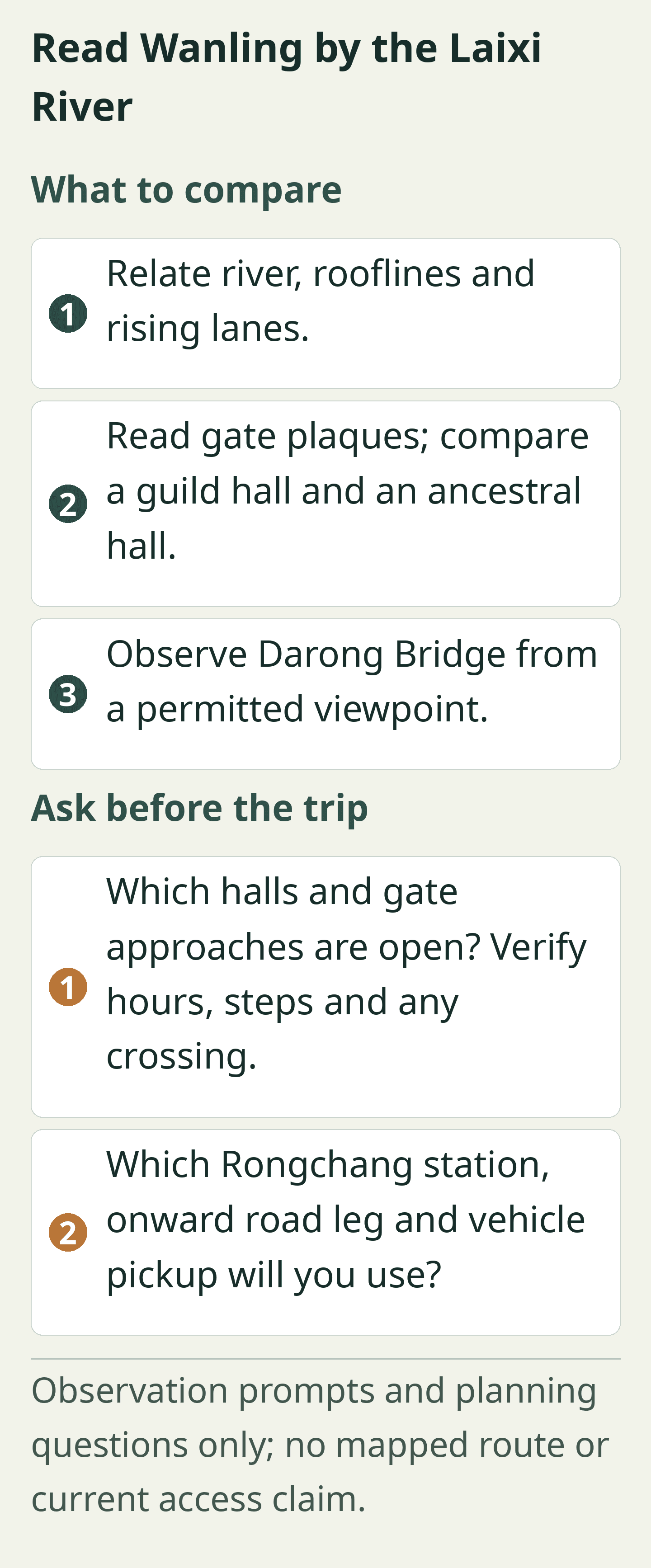
Original localized observation and planning card; all labels also appear as selectable text below. Observation prompts and planning questions only; no mapped route or current access claim.
Original editorial observation and planning card based on this article; no reference photograph reused. Not a photograph or geographic map.
Read Wanling by the Laixi River
What to compare:
- Relate river, rooflines and rising lanes.
- Read gate plaques; compare a guild hall and an ancestral hall.
- Observe Darong Bridge from a permitted viewpoint.
Ask before the trip:
- Which halls and gate approaches are open? Verify hours, steps and any crossing.
- Which Rongchang station, onward road leg and vehicle pickup will you use?
Observation prompts and planning questions only; no mapped route or current access claim.
Solve the Rongchang connection in both directions
Wanling belongs in a Rongchang itinerary, but reaching Rongchang is not the same as reaching the old-town entrance. Compare the full journey from your accommodation, including the local road leg, rather than choosing transport by the shortest rail segment alone.
If taking a train, check the exact station on the ticket and arrange the onward journey independently. The railway-stations guide covers general station-name precautions. No current direct bus or train-to-gate connection was verified for this guide.
For the return, retain a pickup location reachable by vehicle and share its Chinese name. The navigation and road-level guide is useful preparation, but local confirmation is still needed. Ask a driver to meet you at a practical road entrance rather than at a bridge or lane accessible only on foot.
Allow a margin between leaving the town and any booked onward train. A leisurely meal, a missed local connection or difficulty locating a vehicle should not force a rushed crossing or an unsafe shortcut. That return margin is part of planning a slow visit, not an afterthought.
About This Guide
Research on 1 October 2026 combined Chongqing civil-affairs history, Wanling's public facility directory, an iChongqing feature and the relevant cultural-relic section of a World Bank-hosted environmental assessment. Suggested pacing and observation questions are editorial synthesis. No author visit or human field review occurred; dated hours and access must be reconfirmed.
Frequently Asked Questions
Q: Are Wanling and Lukong different towns? A: Rongchang's Lukong Ancient Town was renamed Wanling in 2013, according to municipal history. Older heritage listings continue to use Lukong for the same settlement.
Q: Is there an admission charge for Wanling Ancient Town? A: The Wanling town-government directory dated 9 December 2025 lists free entry to Wanling Ancient Town. Check current arrangements and any separately offered activity before visiting.
Q: Can I visit the heritage halls whenever the streets are open? A: Wanling's December 2025 directory lists the historic building group at 09:00–18:00 while describing the town as open all day. An open street does not establish access to every heritage interior.
Q: Must I cross Darong Bridge to enjoy the visit? A: Darong Bridge can be appreciated from a permitted viewpoint without crossing it. Cross only when the approach is open and suitable for everyone in your group.
Q: How much should I try to include? A: A first Wanling visit can focus on the Laixi River, Darong Bridge, one gate and one open hall. Add more after checking energy, weather and your return connection.

Traveler comments
Share a recent experience or ask a practical question about this guide.